Weather Watchers
Related: About this forumEl Nino's Return Grows More Likely as La Nina Weather Pattern Winds Down
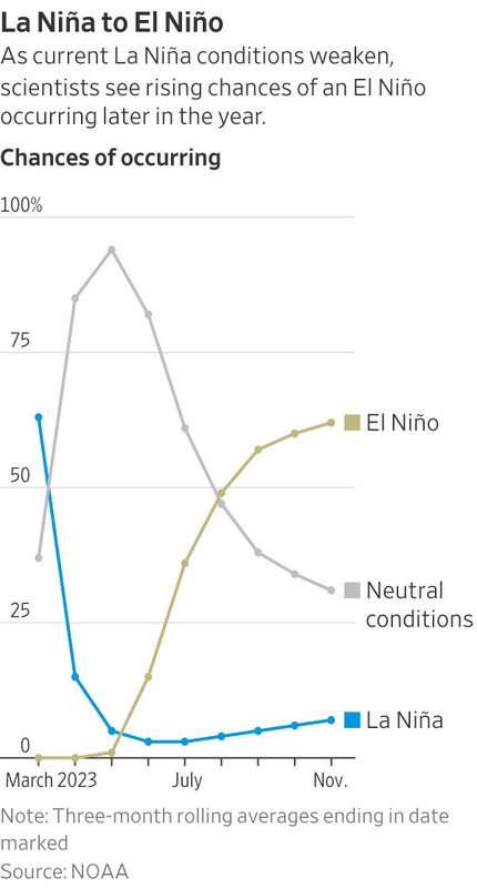
Goodbye, La Niña. Hello, El Niño?
The reign of the weather phenomenon La Niña is coming to an end, as the powerful pattern eases to a more normal state before its counterpart, El Niño, becomes increasingly likely to form later this summer, according to scientists at the National Oceanic and Atmospheric Administration.
The Pacific is shifting to a normal or neutral pattern of surface temperatures and wind strength for the next several months, according to Dan Collins, a meteorologist at the NOAA Climate Prediction Center in College Park, Md. The probability that an El Niño will form during the three-month period beginning in June is just over 50%, a figure that rises to 60% by late summer or early fall, he said.
La Niña is part of a shifting weather pattern known as the El Niño-Southern Oscillation, or ENSO, that occurs when unusually strong trade winds push warm Pacific Ocean surface waters west toward Asia. This causes cold water to rise to the surface in the central and eastern Pacific Ocean. La Niña has had a pronounced effect on weather, such as prolonging the drought in the Southwest.
El Niño, by contrast, occurs when these trade winds weaken and warmer-than-normal water sloshes from the western Pacific Ocean to the eastern Pacific. The ENSO pattern shifts back and forth irregularly every two to seven years, bringing changes in ocean surface temperature and disrupting the wind and rainfall patterns across the tropics, according to NOAA.
The computer models from NOAA and other meteorological agencies are in agreement that ENSO is easing over the next three months, according to Dr. Collins. But beyond that, there is less certainty about the arrival of El Niño.
(snip)
El Niños typically reduce rainfall across parts of Southern and Southeast Asia, while at the same time bringing precipitation to the Western U.S. and parts of South America. Previous El Niño events in 1997-1998 and 1982-1983 caused strong storms to batter the West Coast, while the Northern U.S. and Canada were drier and warmer. El Niño patterns are also associated with fewer Atlantic hurricanes during the summer and fall because of stronger upper-level winds.
More..
https://archive.is/JXcwj#selection-257.0-271.419
 = new reply since forum marked as read
Highlight:
NoneDon't highlight anything
5 newestHighlight 5 most recent replies
= new reply since forum marked as read
Highlight:
NoneDon't highlight anything
5 newestHighlight 5 most recent replies

jimfields33
(17,986 posts)intrepidity
(7,737 posts)
love_katz
(2,709 posts)The Left Coast has really needed the relief from the drought. I have been super grateful to have something approximating a "normal" winter. I hate excessively hot summers, which are what we get during El Nino years. 
