Welcome to DU!
The truly grassroots left-of-center political community where regular people, not algorithms, drive the discussions and set the standards.
Join the community:
Create a free account
Support DU (and get rid of ads!):
Become a Star Member
Latest Breaking News
Editorials & Other Articles
General Discussion
The DU Lounge
All Forums
Issue Forums
Culture Forums
Alliance Forums
Region Forums
Support Forums
Help & Search
Photography
Related: About this forumGentle Storm Over England
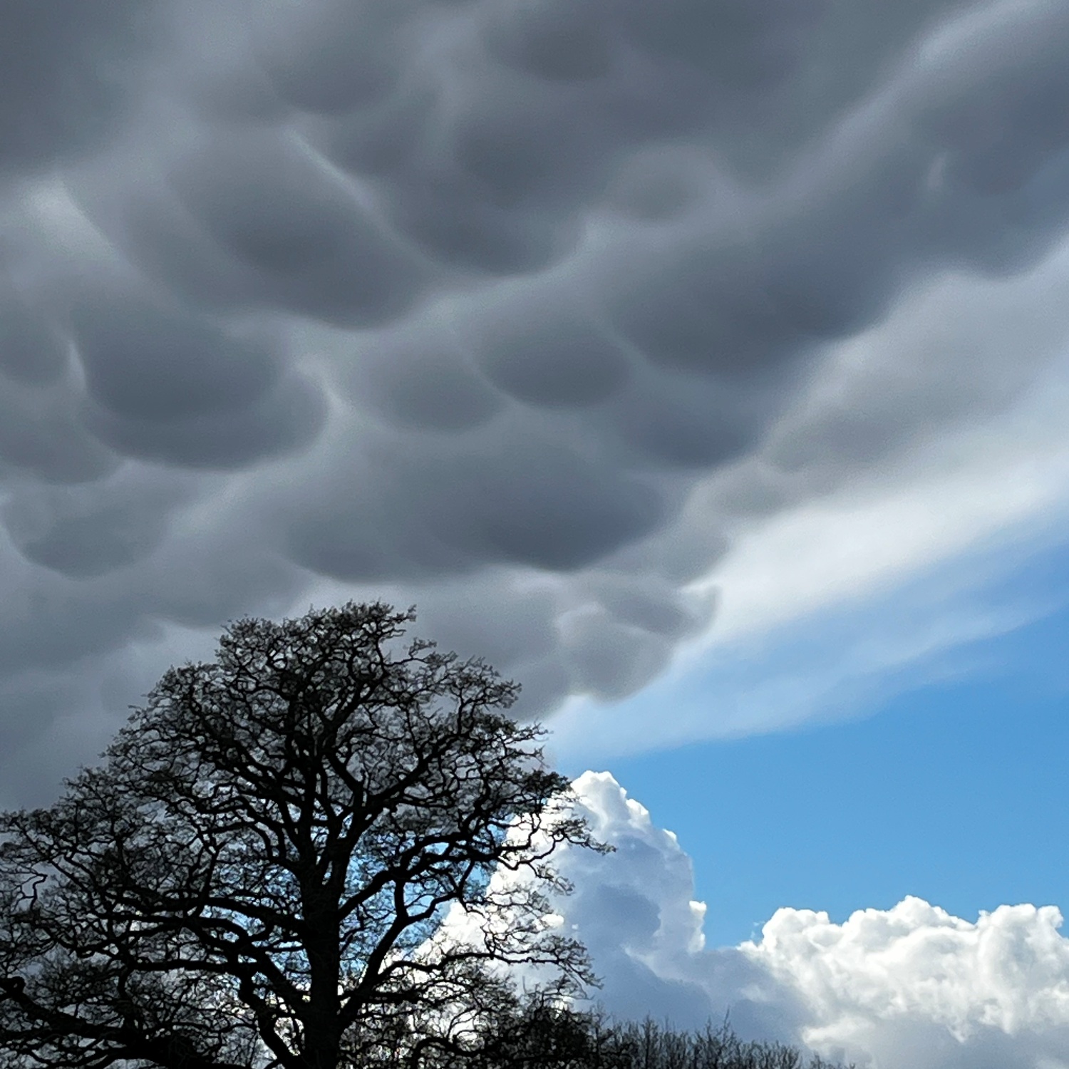
Sara Driscoll...spotted this sky over Marchwood, Hampshire, England while out with her toddler.
The underside of a passing Cumulonimbus storm cloud revealed a striking display of mamma cloud features. These are rounded, pouch-like formations that hang from the underside of a cloud layer, the most dramatic like these being found beneath the spreading canopy of storms...
Another wonder of our cloud covered Pale Blue Dot from the Cloud Appreciation Society
7 replies
 = new reply since forum marked as read
Highlight:
NoneDon't highlight anything
5 newestHighlight 5 most recent replies
= new reply since forum marked as read
Highlight:
NoneDon't highlight anything
5 newestHighlight 5 most recent replies
= new reply since forum marked as read
Highlight:
NoneDon't highlight anything
5 newestHighlight 5 most recent replies
Gentle Storm Over England (Original Post)
SorellaLaBefana
21 hrs ago
OP
Actually, not so gentle. Those are often called hail clouds. Usually called that, here in Tornado Alley.
highplainsdem
20 hrs ago
#3

surfered
(14,260 posts)1. Beautiful!

niyad
(134,016 posts)2. Reminds me of looking at a package of dinner rolls.

highplainsdem
(63,068 posts)3. Actually, not so gentle. Those are often called hail clouds. Usually called that, here in Tornado Alley.
https://en.wikipedia.org/wiki/Mammatus_cloud
Lots of photos here:
Mammatus clouds are ominous and beautiful
https://earthsky.org/earth/mammatus-clouds-best-photos-and-info/
European site:
The beauty and mystery of mammatus clouds
https://www.severe-weather.eu/learnweather/severe-weather-theory/mammatus-clouds-mk/
Mammatus are most often associated with anvil clouds and also severe thunderstorms. They often extend from the base of a cumulonimbus cloud, but may also be found under altostratus, and cirrus clouds, as well as volcanic ash clouds.[4] When occurring in cumulonimbus, mammatus are often indicative of a particularly strong storm. Due to the intensely sheared environment in which mammatus form, aviators are strongly cautioned to avoid cumulonimbus with mammatus as they indicate convectively induced turbulence.[5] Contrails may also produce lobes but these are incorrectly termed as mammatus.[1]
Mammatus may appear as smooth, ragged or lumpy lobes and may be opaque or translucent. Because mammatus occur as a grouping of lobes, the way they clump together can vary from an isolated cluster to a field of mammae that spread over hundreds of kilometers to being organized along a line, and may be composed of either unequal or similarly sized lobes. The individual mammatus lobe average diameters of 1–3 kilometres (0.6–1.9 mi) and lengths on average of 1⁄2 kilometre (0.3 mi). A lobe can last an average of 10 minutes, but a whole cluster of mamma can range from 15 minutes to a few hours. They are usually composed of ice, but also can be a mixture of ice and liquid water or be composed of almost entirely liquid water.
True to their ominous appearance, mammatus clouds are often harbingers of a coming storm or other extreme weather system. Typically composed primarily of ice, they can extend for hundreds of miles in each direction and individual formations can remain visibly static for ten to fifteen minutes at a time. They usually appear around, before, or even after severe weather.
Lots of photos here:
Mammatus clouds are ominous and beautiful
https://earthsky.org/earth/mammatus-clouds-best-photos-and-info/
European site:
The beauty and mystery of mammatus clouds
https://www.severe-weather.eu/learnweather/severe-weather-theory/mammatus-clouds-mk/
Mammatus clouds form with large cumulonimbus clouds when cool air sinks down, forming these round, bubbly clouds. The ongoing turbulence inside the thunderstorm cloud causes mammatus to form, typically under the anvil. Aviators will avoid flying near them due to the turbulence likely to be expected in the region.
As updrafts carry precipitation-enriched air to the cloud top, upward momentum is lost, and the air begins to spread out horizontally, becoming part of the anvil cloud. The saturated air is heavier than the surrounding air and sinks back towards the earth because of its high concentration of precipitation particles (ice crystals and water droplets).
The temperature of the subsiding air increases as it descends. However, since heat energy is required to melt and evaporate the precipitation particles contained within the sinking air, the warming produced by the sinking motion is quickly used up in the evaporation of precipitation particles. If more energy is required for evaporation than is generated by the subsidence, the sinking air will be cooler than its surroundings and will continue to sink downward.
Since these clouds are associated with unstable air masses and thunderstorms, mammatus is often associated with hail, heavy rain, and lightning strikes.

Grins
(9,519 posts)4. "Mammatus" because they look like boobies!
There was another name for them when I was in flight school…

Zorro
(18,874 posts)6. Yep. Those clouds mean "find some shelter"

1WorldHope
(2,152 posts)5. Usually a sign of hail, right?
highplainsdem
(63,068 posts)7. Yes. See reply 3.