Tropical Storm Francine tracker: Storm forecast to make landfall in Louisiana as a hurricane
Source: ABC News
September 9, 2024, 11:27 AM
Tropical Storm Francine has formed in the Gulf and is forecast to strengthen to a hurricane before making landfall in Louisiana.
Francine is forecast to be a Category 1 hurricane with 85 mph winds by the time it makes landfall on Wednesday afternoon.
A hurricane watch has been issued in Louisiana, from Cameron to Grand Isle.
A storm surge watch is in effect from Texas to the Mississippi-Alabama border.
Read more: https://abcnews.go.com/US/tropical-system-gulf-forecast-strengthen-hurricane-ahead-louisiana/story?id=113509204
Link to tweet
@fema
·
Follow
We encourage everyone in the path of Tropical Storm #Francine to prepare now. Please listen to your local officials for updates.
Make sure you have different ways to receive alerts & information from your local officials.
More info from @NWS ⤵️
National Weather Service
@NWS
Tropical Storm #Francine Key Messages...
Disturbance Becomes Tropical Storm Francine. Expected to Intensify With Storm Surge and Hurricane Watches Issued For the Louisiana Coast. http://hurricanes.gov
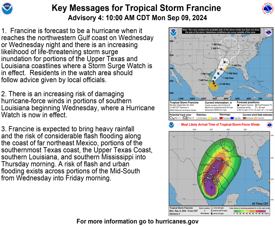
KEY MESSAGES: 1. Francine is forecast to be a hurricane when it reaches the northwestern Gulf coast on Wednesday or Wednesday night and there is an increasing likelihood of life-threatening storm surge inundation for portions of the Upper Texas and Louisiana coastlines where a Storm Surge Watch is in effect. Residents in the watch area should follow advice given by local officials. 2. There is an increasing risk of damaging hurricane-force winds in portions of southern Louisiana beginning Wednesday, where a Hurricane Watch is now in effect. 3. Francine is expected to bring heavy rainfall and the risk of considerable flash flooding along the coast of far northeast Mexico, portions of the southernmost Texas coast, the Upper Texas Coast, southern Louisiana, and southern Mississippi into Thursday morning. A risk of flash and urban flooding exists across portions of the Mid-South from Wednesday into Friday morning.
11:31 AM · Sep 9, 2024
 = new reply since forum marked as read
Highlight:
NoneDon't highlight anything
5 newestHighlight 5 most recent replies
= new reply since forum marked as read
Highlight:
NoneDon't highlight anything
5 newestHighlight 5 most recent replies

RussBLib
(9,490 posts)....is what I hope I can say come Tuesday or Wednesday. Meanwhile, we have had 4-8" of rain along the South Texas coast over the last week, everything is saturated, and forecasters predict we could get 4-6" more by Tuesday. All this after a horrible drought. Storms keep missing our two primary lakes, Falcon and Amistad, while closer to the coast, we're almost drowning.
And our area is finally getting its first water desalination plant.
https://russblib.blogspot.com/?m=1

slightlv
(3,726 posts)bad news about the rainfall missing Lake Amistad. I was down by Harligan, Corpus, Galveston, and South Padre most of the time in my 20's. Where bouts are they building the plant? And to how much of Texas will it serve?
RussBLib
(9,490 posts)1,000,000 gallons of drinkable water per day. That's the current goal. And it is expected to stay here, not be shipped anywhere else in TX. To be built out highway 100 close to the current LMWD Port Isabel plant. (Laguna Madre Water District)
https://myrgv.com/local-news/2024/07/26/drinkable-seawater-port-isabel-to-build-desalination-plant/
https://russblib.blogspot.com/?m=1

LeftInTX
(29,022 posts)It went to Laredo and Monterrey.
In Laredo, dewpoints dropped by 20 degrees.
In Monterrey, dewpoints dropped by 15 degrees. (Hurricane center referred to it as a barrier jet in the Sierra Madres??)
It also impacted Houston area. Their dewpoints dropped by 20 degrees.
The dewpoint in SA when I went walking last night was 49 degrees. A week ago, it was 70. It was too cold for me..LOL
I'm still shivering!
It seemed to have missed the Rio Grande Valley.
Anyway, the cold front is gonna push this thing east.
RussBLib
(9,490 posts)...latest radar shows a sharp turn to the NW. IOW, headed right for us. But the predicted path turns back to the NE towards Louisiana, the poor bastards.
And we got a very slight reduction in dew points here on the coast.
https://russblib.blogspot.com/?m=1
LeftInTX
(29,022 posts)It brings back traumatic memories..LOL
We watched the damn thing fizzle on Brownsville's radar in real time! Our great white hope (or I should say wet hope) completely fizzled like a wimpy thunderstorm on the radar. All of drought stricken Texas was watching in real time and in horror!
Everyone accused the drought of killing Don!
Don apparently left a few wet roads and puddles in its wake!
The NWS had fun with the aftermath.

Expectations
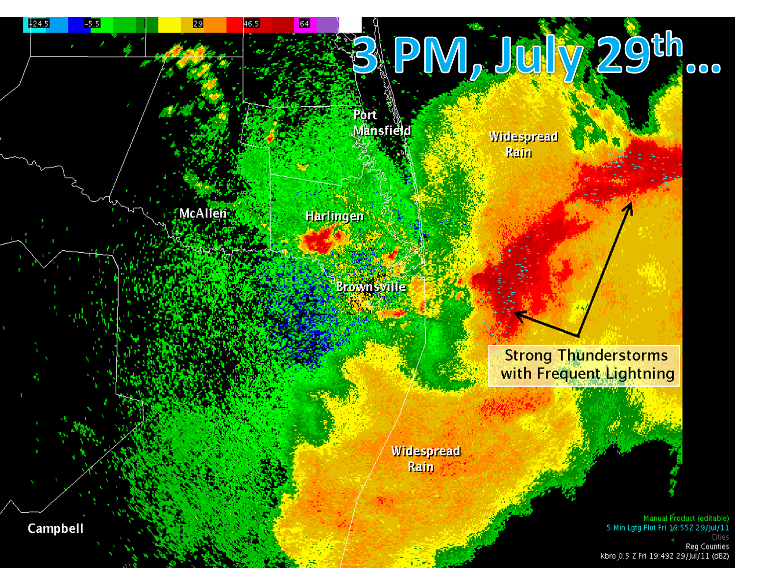
Reality
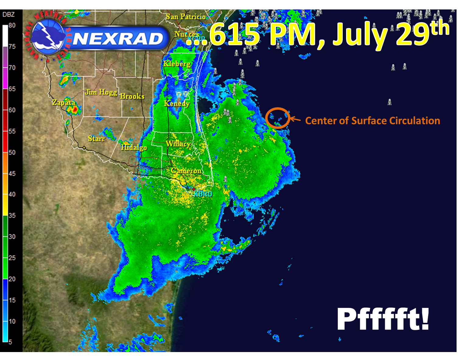
The Best Laid Plans: Intense thunderstorms immediately east of South Padre Island (left) produced quite the light show, according to residents and visitors (light blue small plus and minus signs inside the red core). In only three hours, the storms had faded to gentle light to moderate rains (right) after spreading over Cameron County. By 8 PM, most of the rain had tapered to sprinkles.
https://www.weather.gov/bro/2011event_tropstormdon

pfitz59
(10,731 posts)I guess the 'government shutdown' is on hold?
OnlinePoker
(5,793 posts)At least in the satellite era.
Response to BumRushDaShow (Original post)
Chin music This message was self-deleted by its author.
orthoclad
(4,254 posts)They describe windspeed, which is only one of several threats from tropical storms.
The main killer is storm surge, when water piles up against the coast and spills inland. This is influenced by coast shape and topography, concurrent tides, and long consistent wind direction (fetch). NWS has worked hard to forecast storm surge; it's tricky.
Flooding is also an issue. A slow-moving storm can drop immense amounts of water on the land, as Houston experienced. The flooding can be immediate from local rainfall, or it can be delayed when upstream waters flow and converge.
Francine is no Katrina, but I hope NOLA is making contingency plans for flooding.